


Remote sensing and photogrammetry
Geo-Ocean UBS uses remote sensing and satellite image analysis to understand marine dynamics and monitor environmental changes. Additionally, the use of drones allows for collecting essential data for research and preservation of coastal ecosystems.
Remote sensing
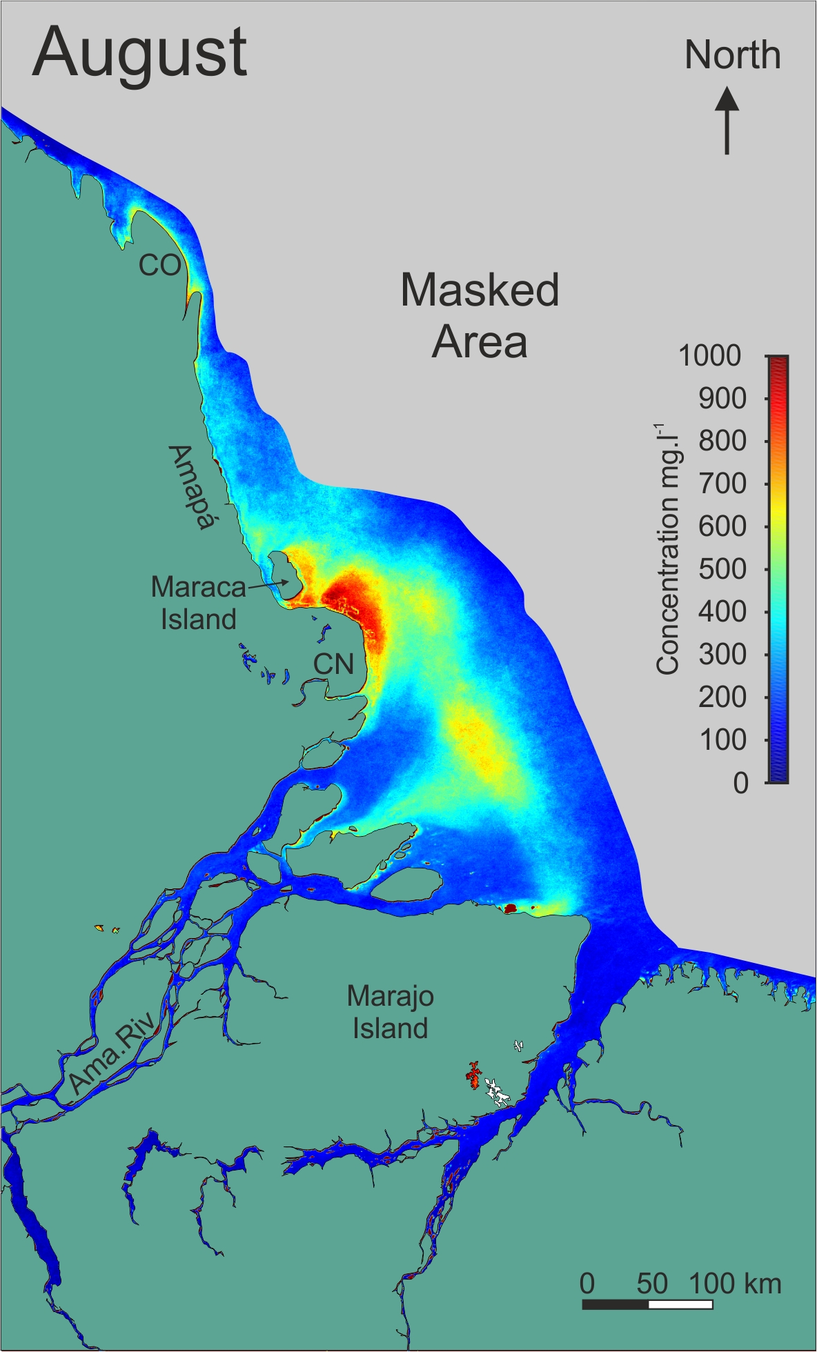
Geo-Ocean UBS is renowned for its expertise in remote sensing, particularly in satellite image processing and analysis.Through advanced techniques, the company is able to provide valuable information on various geographical and environmental aspects. Analyzing the distribution of suspended matter and sediment fluxes sheds light on marine dynamics and sediment transport in coastal and estuarine environments. We can observe such results below, presenting the study of Suspended Matter (M.E.S) at the mouth of the Amazon River.
The topographic maps provided by Geo-Ocean UBS offer detailed visualization of terrain topography, facilitating urban planning, natural resource management, and natural risk assessment.
Furthermore, analyzing the evolution and distribution of vegetation allows for monitoring environmental changes such as deforestation and urban expansion. With its remote sensing capabilities, Geo-Ocean UBS provides essential tools and knowledge to support strategic decisions in land management and environmental preservation.
Photogrammetry
Through the use of drones such as the eBee, Phantom 4 Pro, and Phantom 4 RTK, Geo-Ocean UBS is able to acquire high-quality aerial images.These images are then used to generate orthophotos and very high-resolution 3D Digital Elevation Models , offering accuracy within a few centimeters. To date, Geo-Ocean UBS has conducted a series of drone survey campaigns (using eBee and Phantom drones) in France and internationally, collecting nearly 57,000 photos, equivalent to approximately 1,700 kilometers of coastline and 3,300 hectares of coastal areas. These valuable data fuel mapping and environmental monitoring projects.
These data, acquired at very high resolution, complement existing topographic data. They are essential for the research and training activities of the laboratory. With this drone database, the laboratory conducts various scientific projects in areas such as mapping coastal environments, with a focus on tidal mudflats that harbor significant biodiversity. It also involves estimating sediment volumes related to transport and erosion issues. As well as coastal vulnerability issues such as coastline evolution and risks of inundation.
Data acquisitions by drones cover a wide range of scientific disciplines, from geology to ecology, including archaeology and spatial planning. These detailed pieces of information deepen the understanding of environmental processes and the complex interactions that shape coastal landscapes. Thus, supporting research efforts and sustainable management initiatives for these valuable ecosystems.
Equipment used

eBee drone

Phantom drone
")
Drone DJI Mavic